
The world's surface has been largely carved up among the world's sovereign states, and each piece is owned by one specific state.1 Boundary disputes do occur, but for the last century or more, the largest frontier of international territorial law has been at sea.
Various categories of territorial waters
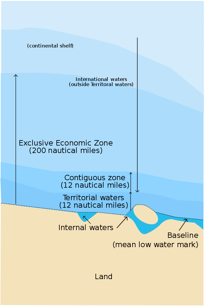
From the 16th century until the early 20th century, international law was relatively simple. A state was generally accepted to be able to lay claim to and control any waters up to three nautical miles2 from its coast, and anything beyond that was the high seas, which were not controlled by any state, and were free to the use of all nations in peacetime. The three-mile limit is traditionally ascribed to the range of contemporary cannon, although it's more likely that it originated with the distance to the horizon from someone standing at sea level.3 Within this limit, a state essentially had the same jurisdiction that it did on land. By WWII, however, this consensus had begun to crack, and a number of countries began asserting much greater territorial jurisdiction, in some cases up to 200 miles out to sea. Much of this had to do with fishing rights, as conservation of fish stocks was an increasing concern. Expanded claims sparked conflict between those nations making them, including Peru, Indonesia, Ecuador and Chile, and the major maritime powers, led by the US, who refused to recognize anything beyond 3 miles.
The issue of territorial seas remained a major problem until 1982, when the third United Nations Convention on the Law of the Sea (UNCLOS) finally codified a set of rules that were reasonably acceptable to all involved parties. Territorial claims were allowed out to 12 miles, although this was balanced by the implementation of "innocent passage", which states that ships (including both merchant and naval vessels) must be allowed to pass freely through territorial waters without being interfered with, so long as they don't fish, make any contact with the country or conduct any sort of naval operations. The state whose territory is being passed through does have rights to set up things like traffic schemes and some limited ability to restrict innocent passage for security reasons, but can't randomly board ships or charge tolls.4
USS Hue City passes through the Strait of Hormuz
But even innocent passage wasn't really enough to satisfy American concerns about the increase in territorial waters, which would begin to overlap and remove some critical straits from the high seas. This was answered by the creation of the doctrine of "Transit Passage", is essentially a stronger version of innocent passage. Unlike innocent passage, it also applies to aircraft and submerged submarines, and it is completely nondiscretionary on the part of the states bordering the strait in question. They are forbidden from interfering with passage of the strait, so long as those on passage make no threat of force against them, although some degree of regulation on subjects like pollution and traffic control is allowed so long as it doesn't hinder passage. Most of the world's major straits, including Gibraltar, Dover, Malacca and Hormuz, are controlled under this regime, although a few are governed by other treaties, which usually have similar provisions.
Porter passes through the Turkish Straits
The most restrictive is the Turkish Straits, which operate under the Montreux Convetion of 1936. This gives Turkey greater control over the Straits (and is probably a major reason why Turkey hasn't signed UNCLOS) but also restricts the passage of warships in peacetime, including those of nations with a coastline on the Black Sea. A notable effect is the classification of the Soviet Kiev and Kuznetzov classes as "aircraft-carrying cruisers" instead of aircraft carriers. The Montreux Convention allows states with borders on the Black Sea to transit capital ships of any tonnage through the Straits, but specifically excludes aircraft carriers from that definition, because the section was largely lifted from the contemporary London Naval Treaty. By not calling them aircraft carriers, the Soviets and later the Russians have been able to move those ships in and out of the Black Sea using a loophole intended for battleship floatplanes.
But the 12-mile limit was hardly enough to allow countries to properly regulate their fishing industries, and UNCLOS also allowed claims of 200-mile Exclusive Economic Zones (EEZs). Within an EEZ, the claiming state has the ability to regulate not only fishing but also all resource extraction from the seabed and surrounding environment. So far, this has basically just meant oil drilling, but in theory it could also cover energy generation and deep-sea mining. Some rights also accrue to states on the continental shelf outside of an EEZ, although this only covers resource extraction and not fishing. Issues surrounding the shelf are becoming increasingly important as the Arctic warms and various nations attempt to draw boundaries near the North Pole. Issues with Part IX of UNCLOS, which covers mineral extraction, have kept the United States from ratifying the convention, although the US government recognizes all other parts of UNCLOS as customary international law and abides by them.5
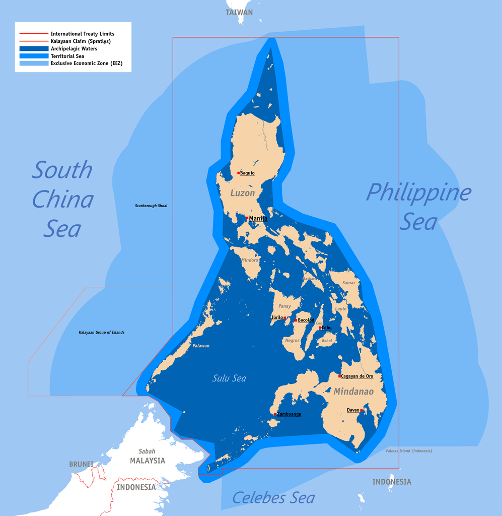
Internal waters of the Philippines
While all of this sounds (relatively) nice and straightforward, there are serious issues. First and foremost, not all waters controlled by a state count as territorial waters. Some waters are classified as internal waters and these are generally treated as equivalent to land in terms of jurisdictional restrictions. For instance, innocent passage does not apply. These waters include not only obvious cases like rivers and lakes, but also many bays and gulfs. The standard under UNCLOS is that any indentation in a coast which can be closed by a 24-mile "baseline" is internal waters. Territorial waters are then measured from this baseline, and not from the coast. Even looser rules apply to archipelagic states, most notably the Philippines and Indonesia, which can basically count anything inside the archipelago as internal waters, although in these cases the right of innocent passage is largely preserved.
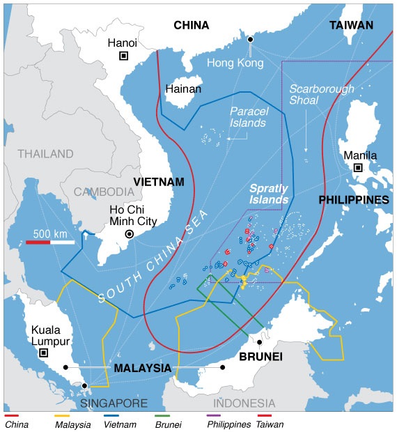
Claims in the South China Sea
Some bodies of water that fall outside of these baselines are also considered internal under customary international law. Even in the days of the 3-mile limit, the Chesapeake Bay, with a 12-mile entrance, was American internal waters, and 32-mile-wide Varanger Fjord in Norway has similar status today. But a number of disputes have arisen over claims by other nations, and the US, interested in preserving freedom of navigation, usually responds by sending warships as a way to register its protest and prevent them being accepted as customary. Libyan claims to the Gulf of Sidra in the 1980s sparked several clashes with the USN. More recently, China has illegally attempted to assert control over large portions of the South China Sea, and the USN has responded by repeatedly sending warships within the claimed territorial waters. Unfortunately, this dispute looks set to continue for years to come.
International law has an important impact on the use of the sea for war, trade, and even recreation. But territorial law is only one aspect of it, and in the future, I will look at others, starting with the status of ships and (to a lesser extent) airplanes.
1 Yes, I am aware that there are exceptions to this. This is not a post on international territorial law on land, and I definitely don't want to go down the rabbit hole that is Antarctica. ⇑
2 This was never 100% uniform among nations, and some claimed up to 20 miles, but the the British, French and Americans all accepted the 3-mile limit. ⇑
3 My main source for this post is International Law for Seagoing Officers. My copy is kind of old, but I've looked into more recent developments. ⇑
4 There's also a contiguous zone from 12 to 24 miles where the state has some law-enforcement powers to stop violations of things like customs and environmental laws. But these are still international waters, and a Navy would be legally allowed to park its ships in someone else's contiguous zone. ⇑
5 A peculiarity of US maritime law is the question of jurisdiction over coastal resources. For complicated reasons, most states control the seabed out to three miles off the coast, while Texas and Florida have control to 9 miles. The federal government has everything from there on out. ⇑
Comments
The first picture shows a "contiguous zone" that extends out another 12 miles past the 12 mile limit of "territorial waters". What's that about?
Great piece Bean.
@Quanticle:
Source
So, if I understand correctly, the "contiguous zone" is a further 12 mile zone in which a nation possesses limited jurisdiction over the the surface and subsurface of the ocean for the purpose of customs, immigration, fiscal and sanitary laws.
I wonder why the UN didn't simply extend the extent of a nation's territorial sea out to 24 miles, instead of establishing a third type of zone.
This actually came from previous international law. (I only found this out yesterday from a link someone posted to the DSL thread on this article.) Under the previous Law of the Sea Convention, states were allowed to enforce that list of regulations out to 12 miles, so they just extended it.
Because International Law is all about compromise. The UN can't actually force anyone to sign onto this treaty, and has to make it palatable to everyone. Most important is the US, who would likely have balked at 24. Also, note that the restrictions are very different from actual territorial waters. The contiguous zone means that someone can put up "please don't dump sewage" signs and investigate ships they think may be smuggling, but they can't legally object to the USN parking a battlegroup 13 miles offshore.
It does seem like a lot of looming conflicts involve territorial water disputes, doesn't it.