
In previous parts, we've discussed the basics of spaceflight, optical recon satellites and other types of recon satellites, but there has been one glaring omission. So far, all of these systems have been directed against land targets, but satellites could also help solve the problems of finding ships far out at sea.
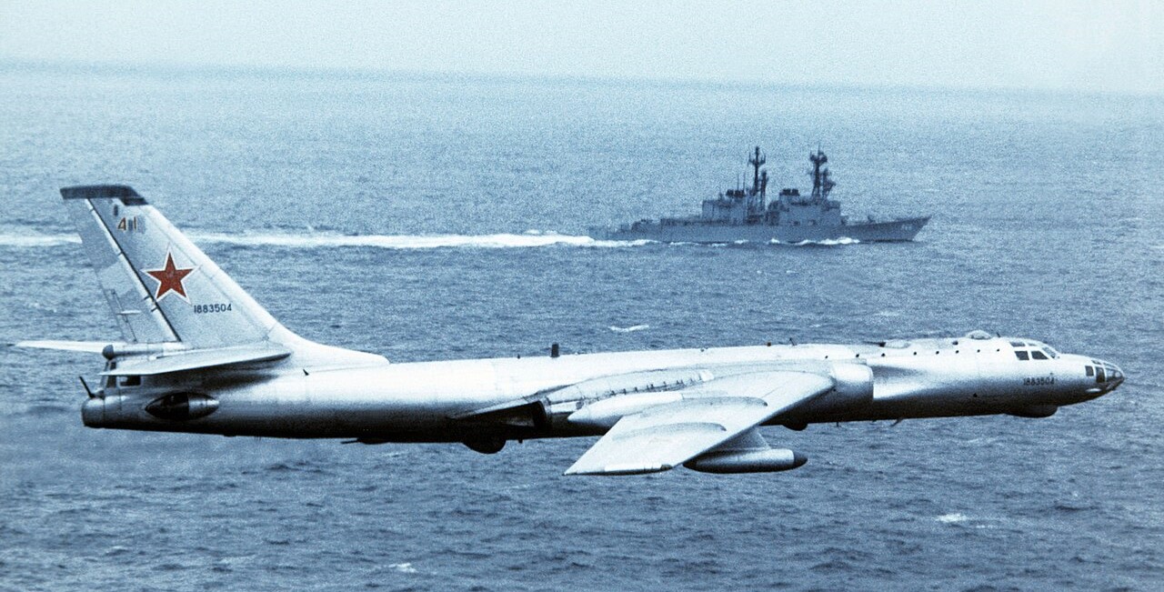
A Soviet Tu-16 recon aircraft flies past a US destroyer
The Soviets1 were the first to take a serious look at this problem, needing as they did some way to find the American carriers, armed with nuclear weapons, for their missile-armed bombers and submarines. Initially, they planned to get a rough fix using shore-based direction-finding apparatus, supplemented with long-range scout bombers. But as the Americans switched away from the use of HF radio, the DF system became less useful, and satellites were the obvious solution. Optical detection was clearly out, given its inability to see through weather and the problems of scanning the entire ocean, then processing and downlinking the data. A radar system would work much better, as it could penetrate clouds and automatically detect targets, greatly reducing the amount of data that needed to be sent to the ground station.
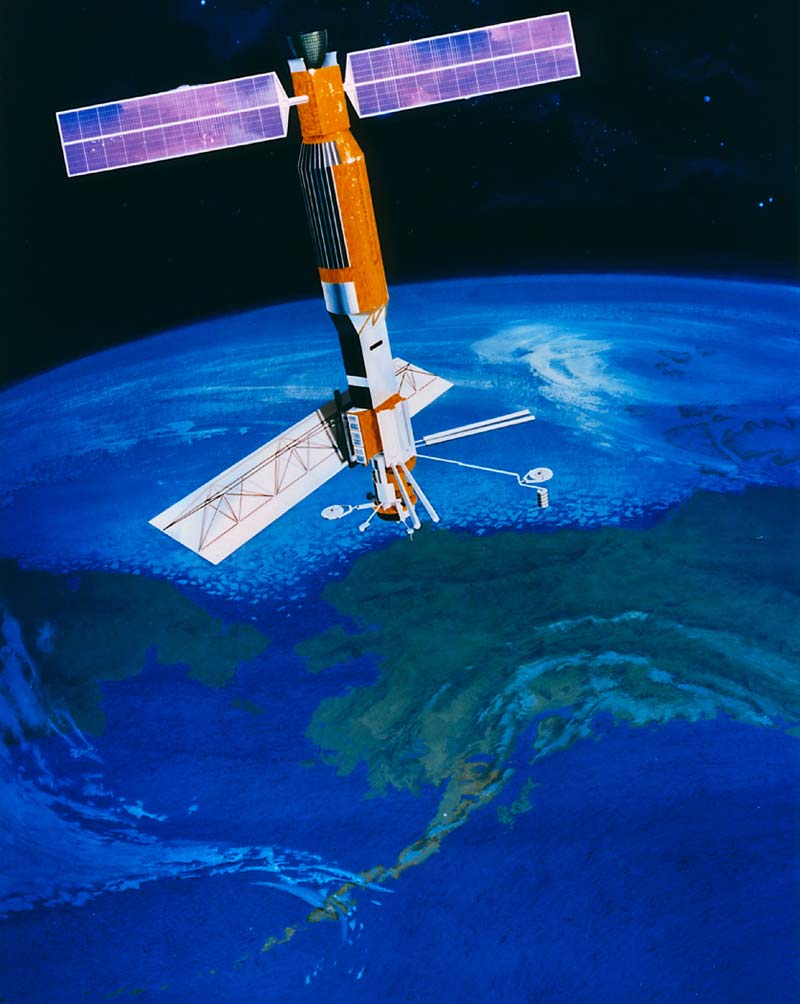
But there was a serious problem. The radar was going to need a lot of power, but it also had to be in a pretty low orbit (250 km or so) to get decent resolution, so solar panels would have produced too much drag. The solution the Soviets came up with was to fit the satellite, designated US-A by the Soviets and RORSAT2 by the US, with a nuclear reactor. Of course, the problem was that even without solar panels, its orbit would decay quickly, dumping a live and very hot nuclear reactor somewhere onto the Earth. It was obvious that this was unlikely to be very popular with anyone who happened to be nearby, so they came up with a plan to separate the reactor core from the rest of the satellite after the 45-day mission was done, and boost it into a 900-km orbit, where it would be safe for several hundred years, giving the dangerous fission products inside plenty of time to decay.
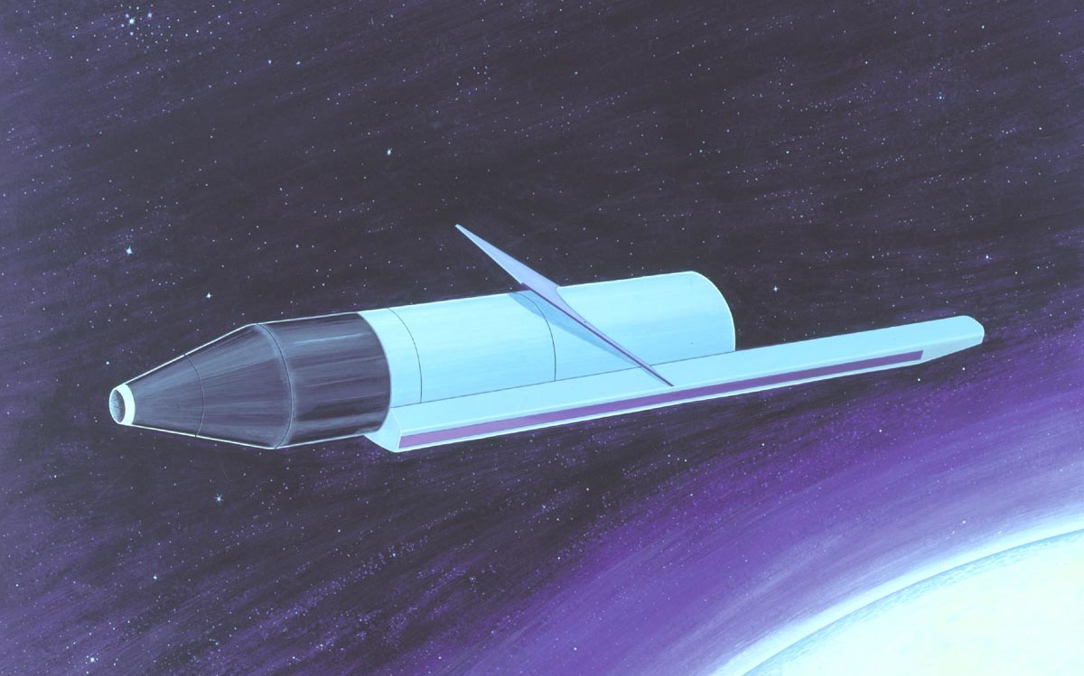
A RORSAT
The result was a formidable challenge to the USN, but not an insurmountable one. First, the RORSAT operated in the X-band, which was badly degraded by rain, so a task force could easily take advantage of passing showers to hide. Second, although it used synthetic aperture techniques to get higher precision than the size of its antenna could provide directly, the need to scan large areas meant that the spot size was much larger then something like Lacrosse. The US estimated it at somewhere between 100 and 150 m across, approximately the length of a typical cruiser/destroyer. If the waves were calm, the majority of the radar return would come from a ship, but heavy seas could swamp anything smaller than a carrier. And because the radar was usually looking from a fairly low angle, it was much more sensitive to ships that were broadside-on than it was to ships presenting bow or stern, so ships could easily hide by turning to minimize their signature.3 Unfortunately for the Americans, the Synthetic Aperture technique apparently gave the satellite great resistance to electronic deception, despite repeated efforts to figure out how to create fake returns.
But missiles take time to reach their target, and ships move, so the Soviets planned to get course data by sending up two RORSATs in the same orbit 20-30 minutes apart. They also had a wide enough swath that they could probably get a second set of readings on the next orbit 90 minutes later, but after that, they wouldn't know what the potential targets were up to for 10 hours or so. The Soviets never sent up more than one pair of RORSATs at a time, although speculation was that they would launch a second pair if war looked likely.4 The other problem with the RORSATs is that they only returned radar data, and while radar is great at telling you where things are, it is somewhat less effective at figuring out what they are. Looking at the picture can let you make some educated guesses (carriers rarely travel alone, while merchant ships almost always do), but it won't tell you which of this group is the carrier, particularly if the commander is trying to mess with you. The obvious solution is to pair the RORSAT with a passive ELINT satellite, which can hopefully identify the carrier's radars. This was designated as US-P (US EORSAT),5, and because it was passive (requiring less power) and could fly at higher altitudes, the nuclear reactor could be replaced by solar panels. Typically one EORSAT was sent up with each pair of RORSATs to handle target identification, a plan the US tried to foil by equipping virtually every combatant with the SPS-49 air search radar.
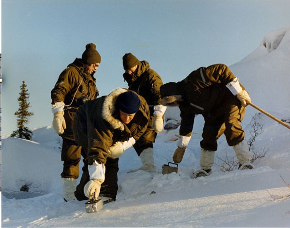
A cleanup team searches for debris from Kosmos 954
The first operational RORSAT flew in 1973, and the Soviets flew one or two pairs a year through the mid-70s, usually timed to coincide with major naval exercises by one side or the other. But things went wrong in late 1977, when the system to raise the reactor into a disposal orbit failed aboard Kosmos 954. On January 24th, 1978, the satellite reentered the atmosphere over the Canadian Northwest Territories, leaving radioactive debris scattered across some of the most inhospitable terrain in North America. The Americans had a team on standby to help out wherever the satellite came down, and it was quickly rushed to the Canadian arctic to help clean up the mess. Much of the reactor had disintegrated at altitude, spreading the debris out enough to minimize the resulting hazard, but a few large pieces had come down and were violently radioactive. Eventually, the area was made safe, and the Canadians sent the Soviet Union a bill for over $6 million for the cleanup. Despite having signed the Space Liability Convention accepting responsibility for any damage done by their spacecraft, the Soviets took until 1980 to pay about $3 million.
But the failure of Kosmos 954, and the resulting bad press, meant a halt to RORSAT flights while the engineers tried to make reactor disposal more reliable. In the meantime, EORSAT had to pick up the slack, with pairs of satellites launched in the pattern that had previously been used by RORSAT. But in 1980, RORSAT flights resumed, with a much longer satellite life (the first satellite made 135 days before the reactor was boosted) and more regular launches, with seven going up in 1981 and 1982. Several satellites of both types monitored the Falklands War, proving the system in operation. Unfortunately, the core ejection mechanism failed again on Kosmos 1402 in late 1982. Fortunately, the core came down over the South Atlantic in February 1983, far away from anywhere people lived. Again, the result was a halt on RORSAT flights, at least until late 1984, with a new secondary booster system. Two were flown each year from 1985 to 1987, with the last going up in 1988 before the entire system was cancelled with the fall of the Soviet Union. The EORSAT system continued to function at least through the mid-2000s. It appears that Russia is attempting to reenter the field with a replacement in the form of the Pion system, the first of which was launched in 2021. It appears to combine active radar and ELINT systems, and thanks to modern electronics, it can operate in a high enough orbit to use solar panels.
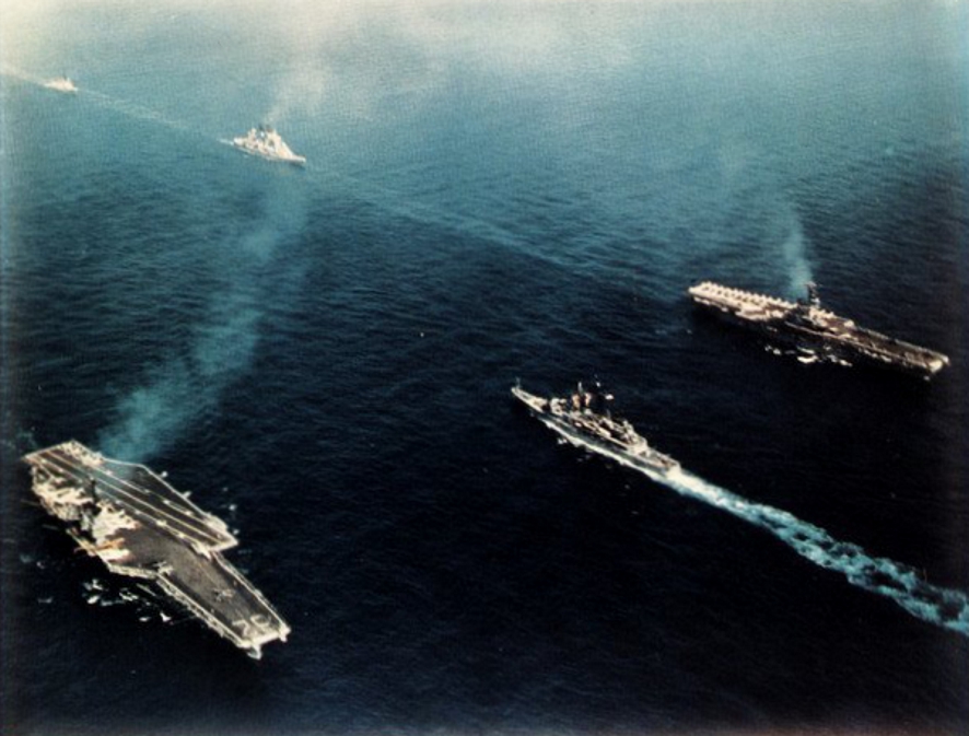
The 6th Fleet in the Mediterranean
The US was somewhat slower to get into the sea surveillance game. Before 1967, the Soviet surface fleet was considered a minor threat compared to their bomber and submarine forces, and it rarely ventured far from port. But the 1967 Six-Day War drew them into the Mediterranean, where the 6th Fleet's carriers formed the backbone of NATO airpower, while the loss of Eilat emphasized the threat that their missiles posed to the American fleet. It increasingly looked like the war would be won by whoever got the first blow in, which meant keeping a careful eye on the Soviet fleet. The USN responded by building a new Ocean Surveillance Information System (OSIS), initially fed by data from the existing HF radio direction-finding network. But the Navy wanted something better, and despite interest in high-altitude aircraft (which could provide continuous coverage) that extended to landing a U-2 on a carrier, eventually decided that satellites were the way to go.
That still left the question of what form the satellite would take. IR cameras were flown as secondary payloads on several KH-8 satellites, but while they worked well enough in tests, it seems likely that issues with poor weather killed it off. Radar was also investigated, but the cost of developing an antenna that would last for a full year in orbit (the US having no time for this commie nonsense about launching every few months) killed it off. That just left ELINT, although the Americans were able to put a few twists on the system the Soviets had used. First, they took advantage of the fact that major naval radars were essentially hand-built, giving each a distinctive "fingerprint" that careful analysis could pick up on. This meant that the US system could get by with a single satellite, estimating course and speed from observations on subsequent passes. Second, the system, initially codenamed White Cloud, used a more accurate method of figuring out the origins of a signal. Instead of a single satellite with a big antenna, it used three small satellites in close formation, which used the slight differences in the arrival time of the signal to pinpoint the emitter on the ground.
A trio of White Cloud satellites pass the Moon
The information from White Cloud was downlinked to a series of operations centers on the ground, then passed out to the fleet, where it formed a critical part of the systems developed for over-the-horizon targeting of weapons like the new Tomahawk anti-ship missile. The satellites, orbiting at around 700 km, can see targets up to 2,000 km off the orbit track, allowing the complete system, which has 4 sets of satellites, to get up to 30 tracks a day on emitters between 40 and 60° of latitude. Accuracy is best when the satellites form a right triangle, and as the orbits converge towards the poles, one of them is offset vertically to preserve the baseline. The version in use since 2001, apparently codenamed Intruder, has only two satellites, but apparently that is enough to do the job. The system has also found other uses, as the satellites pick up emitters ashore as well as at sea, and today, data is regularly passed to users outside the USN.
As the USN got deeper into the surveillance game, interest grew in active radar, and in the late 70s, development began on a project known as Clipper Bow, which would in theory be able to detect not only ships but also missiles, and identify ships based on the resulting images. However, this soon ran well over budget, and Congress killed the program in 1979. The 80s saw several other plans for orbital radars targeted at both ships and aircraft, at least in large part to help the USN win the Outer Air Battle against missile-armed Soviet bombers. The discovery of the Slow Walker capability on the DSP constellation removed much of the need for this, and more recent efforts have focused on infrared, although there has been discussion in 2025 about space-based radar to replace AWACS. It's very unclear how that will turn out, as Congress seems pretty determined to keep AWACS.
Seasat
But all of these systems were focused on detecting surface ships, and the holy grail of naval satellites was a system capable of picking up submarines. Throughout most of the Cold War, both sides tried to break the blanket of invisibility that shrouded submarines. Most methods focused on detecting the changes the submarine wrought in the sea, whether they be using radar to pick up some changes in turbulence or large wake structure on the ocean's surface, detecting the heat signature from a submarine's reactor, or somehow sensing bioluminescence produced by it's passage.6 Some of these could produce detectable signatures for fast, shallow submarines, but none seemed able to provide useful data in practice. Reports that Seasat was shut down prematurely because it was picking up submarines appear to be entirely unfounded given the number of superior sensors that have since flown. Also proposed was the use of blue-green lasers that could probe the depths and detect submarines directly, but despite the recent use of such technology in the ALMDS, a space-based version seems unlikely given the narrow beams of lasers and the volume of the oceans. Also worth considering is that many of these stories date back to the 80s, when the Reagan Administration was waging an active campaign to force the Soviets to spend lots of money (which they didn't have) chasing wild technological geese, which involved a lot of lying about what the US was working on. The only areas where satellites have made a major contribution to submarine warfare are communications and oceanography.
China has recently entered the field of naval satellites. Starting in 2010, they began flying the JB-8 family, which closely resemble White Cloud, and they have also invested in SAR satellites. Given the capability of the civilian TerraSAR-X for maritime monitoring, it would be surprising if none of the Chinese satellites could do the same, and there are reports of the use of wake detection from SAR imagery as well. The Chinese are also apparently looking at using optical satellites for surveillance, something made possible by high-capacity communication links and dramatic advances in image processing which could allow automatic detection and classification of surface ships. Obviously, details are still far from certain, but it looks as if the satellite systems of the US and China (and maybe Russia, if they have satellites up) are particularly effective at hunting surface ships.
But all of the information collected by various recon satellites would be useless without some way to get it to operators in the field. And while terrestrial methods are sometimes used for such tasks, satellite communication has been vital not only in this task, but in allowing the military to use more bandwidth in general. We'll take a look at them next time.
2 Radar Ocean Reconnaissance SATellite. ⇑
3 It's also possible that the decision to make the Burke stealthy was at least in part to help hide from this system, although that's speculation on my part. ⇑
4 Note that the Soviets were never able to build satellites with a particularly long life, so they launched a lot instead. We'll come back to this when I talk about the Soviet military space program. ⇑
5 ELINT Ocean Reconnaissance SATellite. ⇑
6 The Soviets fitted their submarines with wake turbulence detectors and their surface ships with IR detectors, although neither seems to have been particularly useful. ⇑
Comments
Taking this phrase literally is so tempting, even though I know it's wrong, that I have to imagine you set it up deliberately...
Weirdly, no. That was a complete accident.
Has any non-acoustic sensor worked at scale against deeply submerged submarines?
Magnetometers / MAD sensors, perhaps? Other than that I can't really think of anything.
I'm not even sure I'd describe MAD as working at scale. It's a useful sensor if you're trying to localize a submarine you've already picked up by other means, or if you need to create a relatively short barrier in fairly shallow water. But you can't search an ocean with it.
How did the prevalence of EORSAT / ELINT methods for locating fleets impact the weight of EMCON type operations in planning? It seems like (especially with '40s-'70s vintage electronics) you trade off 'I can see the missile / bomber coming in at greater range' against 'I am making it easier for the bomber to find me', and I imagine that tradeoff depends on where the fleet is operating.
Also, do modern naval ships (at least in peacetime) generally run with AIS on to avert collisions with the merchant marine? I believe that was an issue in one of the DDG collisions, but not sure if they've changed that since then.
Yeah, pretty much. Note that EMCON wasn't new, although there was a shift from "only HF can detect us at range" to "our radars can be picked up, too".
No idea on AIS.
Back when I was still in, we did generally run with AIS on when we weren't expecting trouble, but the precise details of what "expecting trouble" consists of, where and when that might pertain, and what we'd do in those cases is most likely classified (and certainly CUI at the very least).
These days, would an ELINT satellite at least be able to easily/reliably identify a carrier group out of the rest of the noise in the ocean? It still wouldn't allow a cheap conventional carrier killer with cruise missiles, but could allow nuclear-armed cruise missiles to be effective, no? That assumes they don't accidentally target a pod of dolphins or a rain storm in the middle of the ocean.
@Garrett: see here.
@Garrett
I think you might have typoed ELINT when you meant radar. An ELINT satellite would have no problem finding a radiating carrier group, and no chance of getting a false positive off dolphins. (It also wouldn't allow direct use of nuclear weapons, which have political problems and don't offer as much standoff as you'd think. Targeting conventional ASMs with some search capability was done in the 80s with TASM.)
As for radar, modern SAR platforms are very much able to identify a ship. You can see results if you look for TerraSAR-X Maritime on Google. (I couldn't find any pictures that looked safe to use here.) The concern there is the tradeoff between search area and resolution, which I don't have a great insight into if we're trying to build a constellation at scale.
You pretty much only need to get the missiles close enough that their own sensors can pick out the carrier group, which will be from much further away than the blast radius of a nuclear warhead. I imagine the main benefit of using a nuclear cruise missile would be the greater damage inflicted, a degree of resistance to some soft or hard-kill countermeasures (as a near miss may be enough) and greater effectiveness in the land attack role if they have that ability.