
Although imaging satellites are the most prominent and best documented form of recon satellites, they are far from the only platforms to carry sensors into space for military purposes. The most common use is signals intelligence (SIGINT), taking advantage of the fact that radio waves generally travel in straight lines well past their target, and can be picked up by a passing satellite. Antennas also produce sidelobes that point in different directions from the main lobe, and satellites can often pick up signals in the lobes pointing up. Lastly, a snooping satellite can make use of the fact that radar signals have to be quite powerful to create a useful return, so even a simple receiver is usually enough to pick up a one-way signal.
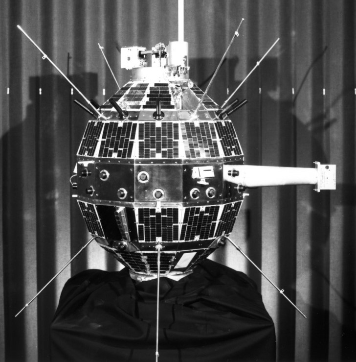
GRAB/SOLRAD-1 is prepared for launch atop Transit 2A
In fact, the first plans to make use of these properties predate spaceflight itself. In the late 40s, engineers realized that they might be able to measure the signals of Soviet air-search radars by listening to signals reflected off the Moon. Initial tests found that the Moon was a surprisingly good reflector, but the cost of an operational program, and the development proper of SIGINT satellites, killed it off.
SIGINT satellites were planned from early on in the American space program, and a system known as GRAB (officially Galactic Radiation And Background, in fact simply for what it would do to Soviet electronic transmissions), was the world's first successful spy satellite. The satellite, with the cover name SOLRAD 1, was launched as a secondary payload with the Navy's Transit 2A navigation satellite and despite weighing only 19 kg incorporated not only the SIGINT system but also a very real science capability, passing significant data on the Sun's X-ray signature. When in SIGINT mode, it was a simple transponder, relaying the signals it picked up to the ground station, where they were recorded for analysis. This gave not only the performance characteristics of the radars, but also their location, thanks to the use of doppler shift and a bunch of math. These were largely focused on Soviet air defense radars, vital information for both Navy and Air Force as they planned nuclear strikes on the USSR.
Poppy
The information from GRAB was valuable enough for follow-on projects, with codenames like Ferret and Poppy. But it soon became apparent that search radars weren't the only things working in the relevant frequency band. The Soviets, wanting something more secure than HF radio and unable to afford a massive investment in cables, were switching to microwave links for their internal communication. This drew interest from the NSA, which promptly began setting up an improved system of SIGINT satellites in near-geostationary orbit.1 These systems are among the most classified in the entire US defense sphere, and have run under many names: Canyon, Rhyolite, Vortex, Magnum, Mercury and Orion. All we can say for sure is that they have massive antennas to capture even the faintest signals, with the latest version, Orion, reported to have a 100m deployable dish.
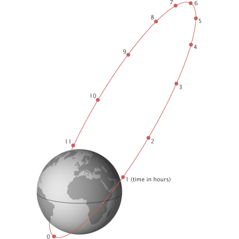
A Molniya orbit with the satellite's position labeled in hours
The geosynchronous SIGINT satellites are supplemented by another group of satellites codenamed Jumpseat and later Trumpet. These used what is known as a Molniya orbit, a way of solving one of the major problems of geosynchronous orbits. Because those tend to be low-inclination, the satellite is never far from the horizon at high latitudes, limiting how much it can see. The best solution for coverage in those areas is a satellite in a very elliptical orbit at a high inclination, and with a period of 12 hours. This ensures that the satellite spends at least 8 hours of each orbit at high latitude over the chosen (high-altitude) hemisphere, while minimizing the time spent over the other hemisphere. The name Molniya comes from a series of Soviet communication satellites that were the first to make use of these orbits.
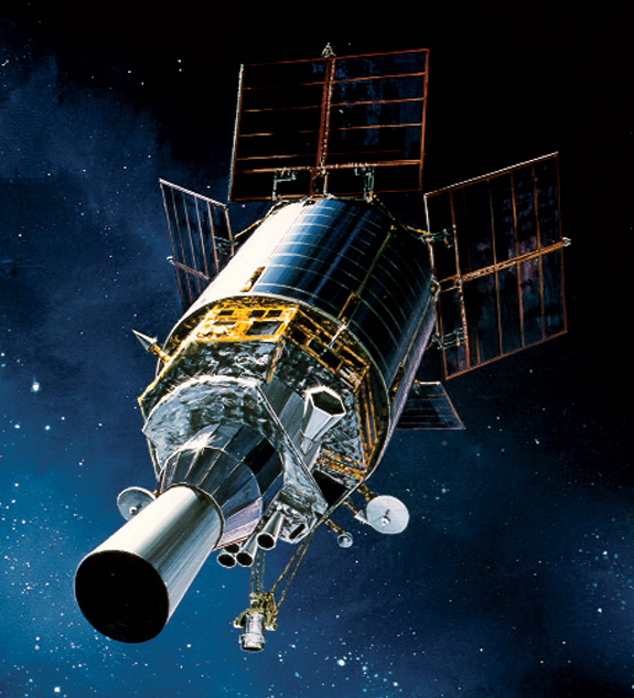
A DSP satellite
The Trumpet satellites also carry a second sensing payload,2 an IR sensor designed to detect ballistic missile launches. The idea of using satellites to give the earliest possible warning of a missile attack dates back to the early days of the space race, with the US attempting to build a system called MIDAS in the early 60s, using a series of a dozen or so polar satellites. But the technology wasn't quite ready to do all of this at a reasonable cost, so it would take until the early 70s for the US to build a practical missile-warning system in the form of the geosynchronous Defense Support Program. Each of these satellites had an IR telescope pointed at the Earth with a linear array spun to cover the entire planet 10 times a minute. This helped to distinguish between stationary IR sources (like forest fires), and moving ones like ICBMs, while the choice of a wavelength heavily absorbed by the atmosphere meant that high-altitude targets stood out well against the relatively dark Earth.
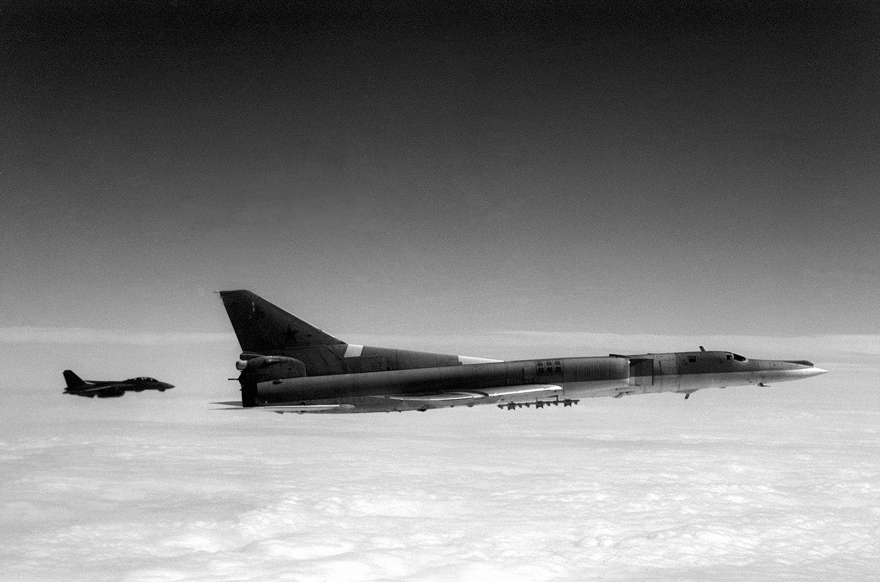
A Backfire is intercepted near a carrier
The DSP soon began to demonstrate important secondary capabilities.3 From the beginning, it proved better than expected at tracking the trajectories of rockets, allowing operators to distinguish between ICBMs and satellite launches, and to get technical data on the tests of new missiles. It also proved more sensitive than anticipated, picking up any number of unanticipated contacts. Some were easy to figure out, like the glints off of satellites, which were code-named Fast Walkers. Others were harder, most notably a series of faint trails over the Soviet Union. Eventually, someone figured out that they started or ended at the bases for the new Tu-22M Backfire bomber, and that the presence of a large, high-altitude aircraft might just be detectable.4 The operators of the DSP spent several years trying to interest the Air Force in this before someone mentioned it to the Navy, who immediately grasped its importance. The availability of early warning of Soviet bomber raids would make it much easier for the carriers to defend themselves, a critical element of the new maritime strategy that was being developed, and this use of the DSP, named Slow Walker, quickly became a high priority. Systems were quickly developed to send the data out to the fleet, who praised it for its timeliness, and later DSP satellites were modified to better see Slow Walkers. Later, dedicated tactical ground stations were built to enhance the use of DSP data for theater missile defense.
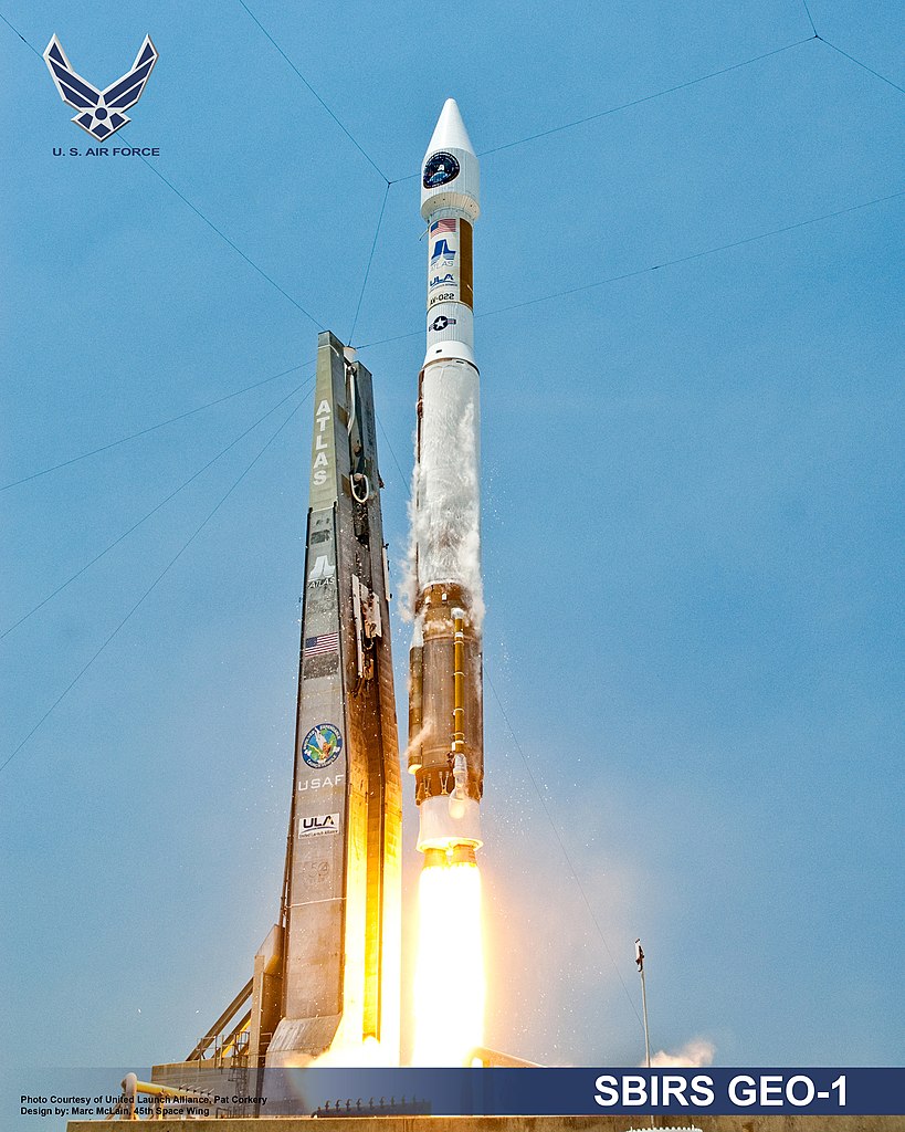
The end of the Cold War and the growing threat of tactical ballistic missiles convinced the DoD that it needed to upgrade its missile warning system, producing Space-Based Infrared System (SBIRS). Initially, the plan was to replace the DSP satellites with new SBIRS satellites in geosynchronous orbit (and the packages on the Trumpet satellites, which would give improved coverage over Russia), while adding an IR constellation in low orbit that could track not only missile launches but reentry vehicles in mid-flight. This was also seen as a way to build on Slow Walker, taking advantage of multi-color sensors5 and improved computing power to track even stealthy aircraft and pass the data directly to tactical users. Unfortunately, this system soon fell victim to budget cuts, and ended up with only two test satellites flown as part of the Space Tracking and Surveillance System. Today, the new Space Development Agency is trying once again to implement something similar, with the rationale that it will allow us to track hypersonic weapons.6
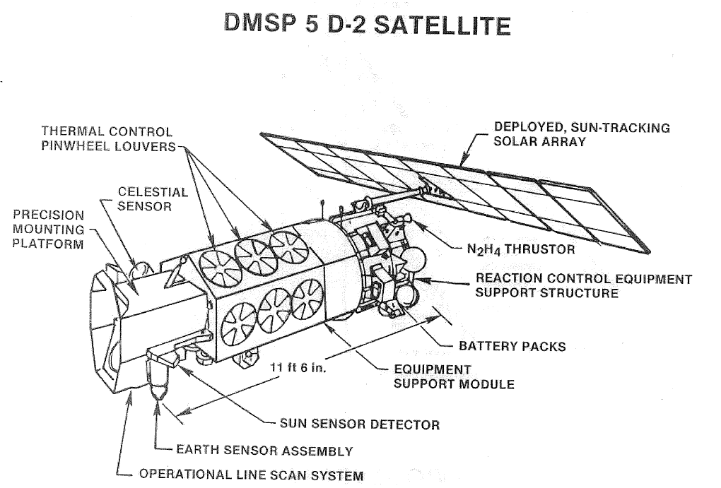
A DMSP Satellite
But IR is good for things other than missile detection. In fact, the very first system to look at the Earth from space, predating even Corona, operated in IR. It was TIROS, a satellite containing an IR TV camera and designed to look at weather. Weather is a vital factor in military operations, and the DOD was quick to get in the game, launching a long series of satellites under the imaginatively-named Defense Meteorological Satellite Program (DMSP). These, and many other weather satellites, are in sun-synchronous orbits and carry a wide variety of instruments that allow them to probe the structure and behavior of the atmosphere. Recently, the US weather satellite program has fallen into turmoil, with programs cancelled left and right, but it looks like the DoD is planning to get data from their own Weather System Follow-on Microwave satellite, which launched in 2024, as well as tapping into the NOAA's Joint Polar Satellite System and Geostationary Operational Environmental Satellite System. The geostationary elements of this system also carry sensors to detect distress beacons, although they are unable to locate said beacons because they are stationary, and the process relies on the doppler shift picked up by satellites in lower orbits.
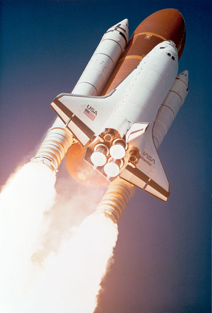
Atlantis carries the first Lacrosse into orbit
But SAR can mean two things in the context of satellite sensors, Search And Rescue or Synthetic Aperture Radar, which brings us to our last topic for this post. The problem with conventional imaging satellites is that they are unable to pierce cloud and darkness, and almost as important, can't pierce camouflage all that well. This was a serious problem when the US was worried about a giant Soviet armored buildup in Germany, and they decided to solve the problem by building a series of satellites that would use radar to produce images of the ground, seeing through bad weather, darkness, and many forms of camouflage. The result was known as Lacrosse, and the first was launched in 1988, on the second Space Shuttle mission after the Challenger disaster. Because radar waves are at least 4 orders of magnitude larger than optical waves, any radar picture is going to be 3 orders of magnitude less precise if taken the same way.7 This isn't particularly useful if you want an actual image, a problem solved through the use of synthetic-aperture radar, a process where signals-processing witchcraft is used to integrate radar returns from various positions along the satellite's orbit to fool the radar into thinking it has a much larger antenna, and thus can build a more detailed picture. Estimated resolution for Lacrosse is probably around 1', and the commercial TerraSAR-X produces 1 meter images for anyone who is willing to pay. More recently, Lacrosse has been replaced by the radar component of the Future Imagery Architecture program, which appears to have gone somewhat better than its optical counterpart. These are notable for using some of the most extreme orbital inclinations I've ever seen, at around 120°.
But all of these satellites have a major limitation. While their resolution is impressive, they can only image a relatively small area at a given time. This is adequate if you want to make sure that the Warsaw Pact isn't stockpiling tanks under camouflages net in eastern Germany, or even if you want to check maritime traffic around, say, Singapore. But the oceans are wide, and you'll need something slightly different if you want to try and find ships in their vastness. We'll take a look at that next time.
1 These are like the geostationary orbits discussed in part one, but aren't precisely circular/equatorial, so that instead of staying in the same place, the satellite traces a path across Earth's surface that repeats every day. ⇑
2 Note that this sort of thing isn't uncommon in the satellite world. There are reports that some KH-11 satellites have secondary SIGINT capabilities, and that a number of imaging satellites flew with small SIGINT satellites as secondary payloads. Very little is known about these. ⇑
3 I should probably also mention the mission of detecting nuclear detonations, a job first done by the Vela satellites in the 60s, and then given to DSP as an obvious extension of the IR sensing mission. ⇑
4 It's unclear exactly why only the Backfires were visible. Some sources say it was the use of afterburner, which is plausible. Also plausible is the presence of multiple large aircraft close together, which is not particularly common. ⇑
5 There's a whole world of figuring out what sort of sensors to deploy and the like, and you can often get surprisingly detailed information by comparing different bands. If you're interested in how all of this works, the old NASA remote sensing tutorial is excellent, if long and rather dated. ⇑
6 I am skeptical that SBIRS can't handle this on its own, and suspect that this is empire-building, exactly as I predicted. I should also caution against looking too deeply into SDA, which is a near-toxic brew of 5-sided thought, Pentagonese, and Silicon Valley buzzwords. ⇑
7 No, this isn't a typo. The radar antenna can be larger, but not larger enough. ⇑
Comments
So if you're covering RORSATs in the next post, is there any reason to build radar sats for spotting aircraft? Stealthy aircraft aren't really designed with the expectation that the radar might be close to 90 degrees overhead. Or is it possible to spot "Slow Walkers" optically with a wide enough field of view?
It's something that has been discussed several times, including as an aspect of the "outer air battle" in the 80s. The problem is that you need a lot of satellites, because they have to be in LEO and twice-a-day coverage isn't really adequate for spotting aircraft. But it seems that IR has won that particular battle, so far as it is still ongoing.
Is it the greater doppler shift that makes aircraft easier to spot optically than ships? I'm not sure why they wouldn't be similarly limited in their field of view otherwise?
No, it's that aircraft are at much higher altitude. They tend to be above weather, and above a lot of the IR-absorbing atmosphere, too. You can basically just look for bright spots, as opposed to having to check every pixel.
Partly it's active vs. passive. To an extremely rough approximation, if you have a fixed mass budget ("over K years you can put N tons of satellite into orbit"), with radar sats, you spend it on many tons of power supply and cooling but few tons of sensor. With IR satellites, you spend it on more tons of sensor.
If I understood it correctly, the infrared aircraft-spotting trick simply doesn't apply to ships. It relies on everything below, say, 10 km altitude being washed together into a locally even "gray" background, against which the planes can stand out as being small, brighter spots. If the aircraft accept a lower range and fly lower, they can evade detection by this means.
So it's just that it's so much easier to pick out the temperature difference of a large, high altitude aircraft against the background of the atmosphere, compared to picking out (say) the brighter wake of a ship against the ocean. That means you can use a wider field of view. I understand that you can't spot ships on IR (because the atmosphere blocks it) and now think I get why they're harder to spot in the visible spectrum than (large, high altitude) aircraft are in IR.
OK, I oversimplified earlier. IR remote sensing is really complicated, and you get different bands that behave quite differently depending on a bunch of stuff. Some are pretty much like visible light, only not. This is what weather sats and stuff like Landsat use. I suspect that most of the vehicle-detection systems work in bands where the object of interest are fairly bright, so you're able to just look for bright things instead of having to check every pixel individually. DSP works in a band where the background is quite dark because of atmospheric absorption, which makes it easier, a handy thing when you're working from GEO with 70s optics and electronics, and it turns out that Backfires were high enough and hot enough to be picked up, too. But you don't have to do that, and it is possible to do reasonable anti-ship detection with IR from LEO. The US flew several IR ship sensors, IIRC on KH-8s. The problem there is that it doesn't work through weather. I suspect this is less of a problem if you're looking for airplanes, which cover a lot more distance, and are unlikely to have convenient clouds to hide in the whole way. There's also the fact that flying at low altitude is bad for fuel consumption. Even if you can avoid the IR system by flying low, it might have serious repercussions on range, particularly because you can't cruise at altitude until you get close like you can if you're trying to avoid terrestrial radar.
That makes sense. Seeing through weather would be a major advantage of RORSATs, just like Lacrosse.