In our recounting of exotic hullforms, it is now time to leave things that are clearly ships, no matter how weird, and venture into the realms where air starts to play a major part in the design, possibly to the point that the thing in question isn't really a ship any more, because the thing isn't limited to operations over the sea. Despite this, they still fall broadly in the realm of naval vessels, as various limitations mean that they rarely see service in purely terrestrial roles.
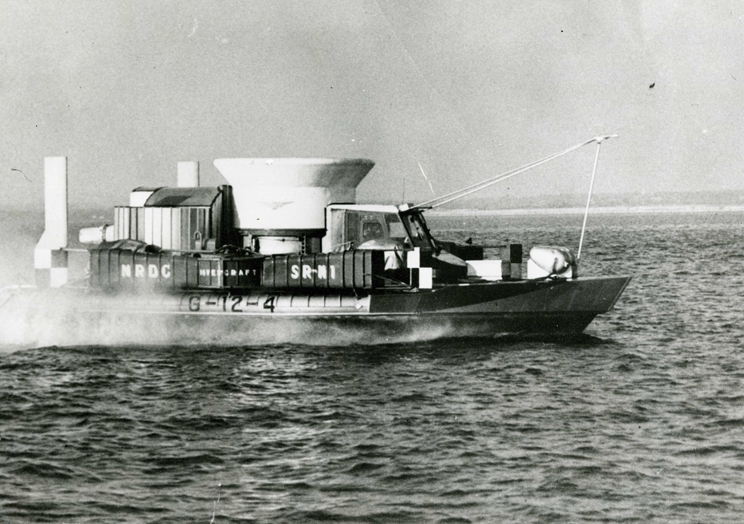
SR.N1, the first true hovercraft
The basic idea is to take advantage of air's much lower density to decrease drag by injecting it underneath the craft to provide lift. Both the simplest and most common version of this is the hovercraft, which at its essence involves using a big fan to pressurize the air under the vessel until the pressure counteracts the weight and lifts it off the ground. The result has effectively no friction and can float over almost any surface, but runs into a simple problem: the amount of air escaping is proportional to the height above the ground, so a low-powered hovercraft will have very little ground clearance, and very limited ability to handle rough terrain or waves, with the first prototype being flummoxed by anything bigger than about 9". While there were some potential uses for this technology, it wasn't really suitable for nautical use, at least until someone suggested adding rubber skirts, which would raise the body of the hovercraft much further and make it possible to cross obstacles. The results were dramatic, with the rebuilt prototype, fitted with 4' skirts, able to handle 3'6" obstacles and operate in 6-7' seas, all while having twice the lifting capacity on the same power. Propulsion was generally provided by aircraft-style propellers, and the lack of any direct contact with the surface meant that speeds of 75 kts or more were fairly easy to achieve, even in moderately rough seas.
Read more...


Recent Comments